

The Silurian in Arkansas, US |
|||||||||||||||||||||||||||||||||||||||||||||||||||||||||||
|
|||||||||||||||||||||||||||||||||||||||||||||||||||||||||||
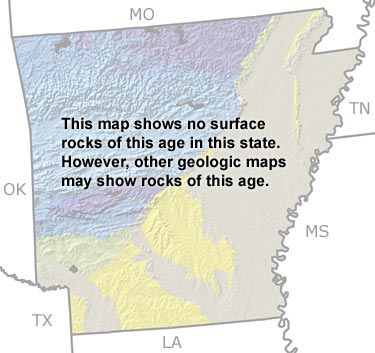
Paleontology and geologyThere was no tectonic activity in Arkansas during the Silurian. Most Silurian-age rocks in the state are either deeply buried or were removed by erosion. The few rocks that remain indicate that a sea covered the state during this time interval. Although not visible on this map, there are small exposures of fossil-poor Silurian shale and sandstone in the Ouachita Mountains of central Arkansas that are indicative of deep ocean waters. Additionally, a few patches of Silurian limestone are exposed in the Ozarks in northern Arkansas. These rocks contain trilobite, crinoid, and brachiopod fossils, indicating that the Silurian sea covering that part of the state was shallow and warm. |
|||||||||||||||||||||||||||||||||||||||||||||||||||||||||||
|
|
|||||||||||||||||||||||||||||||||||||||||||||||||||||||||||


|
site tour |
about the site |
site map |
site credits |
page credits |
help |
FAQs |
contact |
||