

The Jurassic in Arkansas, US |
|||||||||||||||||||||||||||||||||||||||||||||||||||||||||||
|
|||||||||||||||||||||||||||||||||||||||||||||||||||||||||||
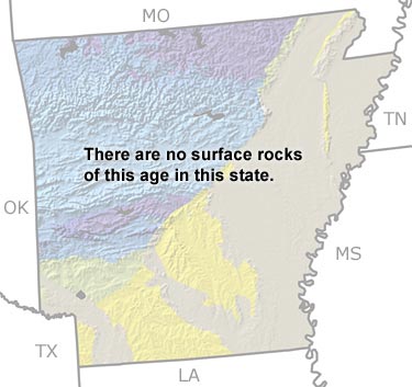
Paleontology and geologyThere are no Jurassic rocks preserved at the surface in Arkansas. Subsurface rocks, however, indicate that northern and central Arkansas were above sea level at this time, while the southern part of the state was flooded by the newly forming Gulf of Mexico. The incipient gulf was narrow, much shallower than it is now, and it did not always have an outlet to the Atlantic Ocean. During times when circulation with the open ocean was restricted, evaporation rates were sometimes so great that salt deposits formed from the highly salty brines. These salt deposits are a major source of bromine used in commercial products from medicines to gasoline additives. Limestone deposits lie over the salt deposits, indicating that good circulation between the Atlantic Ocean and the Gulf of Mexico had returned by the end of the Jurassic. |
|||||||||||||||||||||||||||||||||||||||||||||||||||||||||||
|
|
|||||||||||||||||||||||||||||||||||||||||||||||||||||||||||

|
site tour |
about the site |
site map |
site credits |
page credits |
help |
FAQs |
contact |
||