The Ordovician in Texas, US |
|||||||||||||||||||||||||||||||||||||||||||||||||||||||||||
|
|||||||||||||||||||||||||||||||||||||||||||||||||||||||||||
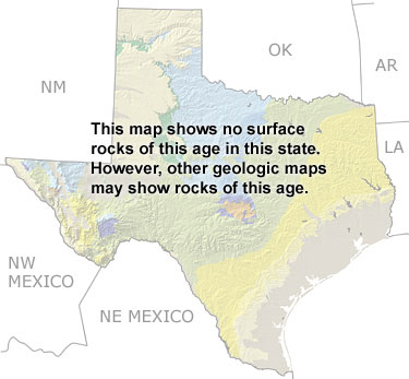
Paleontology and geologyDuring the Ordovician, most of Texas lay under a vast shallow sea in which extensive deposits of limestone and dolostone were formed. Although not visible on this map, some well known Ordovician formations (the Ellenburger Dolostone and the Maravillas Chert) are exposed around the Llano Uplift, the Marathon Basin, and the Franklin Mountains in far west Texas. Fossil cephalopods, gastropods, and brachiopods are known from these areas. |
|||||||||||||||||||||||||||||||||||||||||||||||||||||||||||