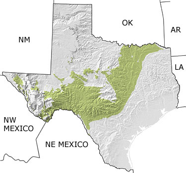
Paleontology and geologyThe Cretaceous is well represented in Texas, shown on this map extending across much of the central state. During this time, seas rose and fell many times, causing the paleo-shoreline to migrate back and forth. This ancient shoreline is visible throughout the Dallas/Fort Worth area and follows Interstate 35 south to San Antonio, then turns sharply west to the Big Bend Region and on into Mexico. Nearshore and coastal lowland conditions were ideal and vast communities of vertebrate faunas and floras thrived. Flowering plants, such as trees and grasses, emerged and began to spread. We find the earliest mammal fossils in Texas in Cretaceous rocks. |