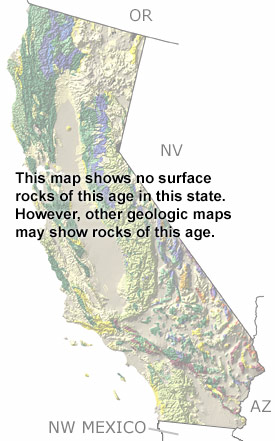
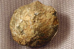
home   Printer friendly version Add to site
Advanced search
Time & Space Fossil Gallery Famous Flora & Fauna
Careers Resources K-12 Collections PaleoPeople

The Silurian in California, US

Silurian in California map

undifferentiated rock units help

Geologic map of CA from California Geological Survey (625 KB PDF)

Choose a time period:

Quaternary
Tertiary
Cretaceous
Jurassic
Triassic
Permian
Carboniferous
Devonian
Silurian
Ordovician
Cambrian
Precambrian

Silurian Fossils
Fossil photos from Silurian in California

Previous (5 slides) Next
Search the fossil gallery

Paleontology and geology

During the Silurian, the western edge of North America was still underwater. Tabulate corals and stromatoporoids (sponge-like animals with calcareous skeletons) dominated the reef communities that were built up in shallow, warm waters on banks and shoals. These warm waters were also teeming with brachiopods, cephalopods, gastropods, bivalves, and crinoids. Although not shown on this map, Silurian sandstones, shales, conglomerates, cherts, dolostones, and some altered sedimentary rocks can be found in the Northern Sierra Nevada, White Mountains, Inyo Range, and places near Death Valley.

Links to more on the Silurian in California

Resources

Resources

Courses and Lectures (showing 1 of 1 listings)

Paleogeography of the Southwestern U.S.: The paleogeography of the southwestern U.S. from 1.8 billion years ago to 10 million years ago. Text and images by Dr. Ron Blakey from Northern Arizona University.

top Top of List

General Reference (showing 1 of 1 listings)

Fossils In Death Valley National Park: The paleontology, geology and natural wonders of Death Valley National Park (and more); many images of fossils; field trips; paleontology links, plus links to Death Valley.

top Top of List


Oregon State Map
Nevada State Map
Arizona State Map
Northwest Mexico Region Map