home   Printer friendly version Add to site
Advanced search
Time & Space Fossil Gallery Famous Flora & Fauna
Careers Resources K-12 Collections PaleoPeople

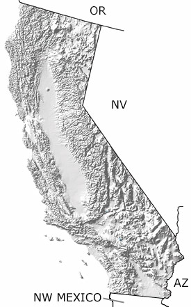
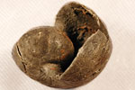
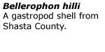
The Permian in California, US

Permian in California map

undifferentiated rock units help

Geologic map of CA from California Geological Survey (625 KB PDF)

Choose a time period:

Quaternary
Tertiary
Cretaceous
Jurassic
Triassic
Permian
Carboniferous
Devonian
Silurian
Ordovician
Cambrian
Precambrian

Permian Fossils
Fossil photos from Permian in California

Previous (7 slides) Next
Search the fossil gallery

Paleontology and geology

Permian rocks in California represent both shallow and deep marine environments inhabited by brachiopods, echinoderms, corals, molluscs, and cartilaginous fish. The shales, sandstone, conglomerates, dolostones, and limestones deposited in these environments are found in Northern California in Shasta and Butte Counties, though not shown on this map.

Links to more on the Permian in California

Resources

Resources

Courses and Lectures (showing 1 of 1 listings)

Paleogeography of the Southwestern U.S.: The paleogeography of the southwestern U.S. from 1.8 billion years ago to 10 million years ago. Text and images by Dr. Ron Blakey from Northern Arizona University.

top Top of List

General Reference (showing 1 of 1 listings)

Fossils In Death Valley National Park: The paleontology, geology and natural wonders of Death Valley National Park (and more); many images of fossils; field trips; paleontology links, plus links to Death Valley.

top Top of List


Oregon State Map
Nevada State Map
Arizona State Map
Northwest Mexico Region Map