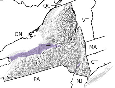
Paleontology and geologyWith a changing sea level in the Silurian, the inland ocean covering western New York became extremely shallow and circulation was poor. Sediments in this sea were periodically exposed as mudflats, and many were quickly eroded away. At times, high rates of evaporation led to the formation of salt deposits. The rate of deposition of sediments was also slower during the Silurian because most of the Taconic Mountains in eastern New York had already been worn down by this time. As a result, there is a relatively limited amount of Silurian rock in New York, shown on this map in the northwestern part of the state. |