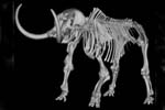
Paleontology and geologyGlacial deposits across New York and the Northeast record the movements of enormous ice sheets that periodically covered parts of North America during the Quaternary. Long Island is a terminal moraine that represents the maximum extent of the most recent glacial advance over 20,000 years ago. The ice sheets helped to shape the landscape of New York, scraping off loose rock materials, gouging the bedrock beneath the ice as it advanced, and scouring river valleys. The Finger Lakes are a famous example of lakes formed by glacial scouring. Mammoths and mastodons roamed the landscape. Late Quaternary river and estuarine deposits also occur in New York. |