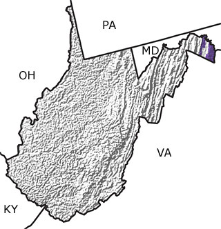
Paleontology and geologyIn the Early Cambrian, a shallow sea flooded West Virginia. Rivers carried eroded sediments and deposited them as sands nearest the shore and muds further out to sea. However, by the Middle and Late Cambrian, the shoreline moved further west across the continent, and the sands and muds eroding off the land did not reach as far east as West Virginia. Trilobites, marine worms, and stromatolites inhabited the subtropical sea that covered the state during this time, and only limy sediments were deposited on the sea floor. These deposits eventually formed layers of limestone and dolostone thousands of meters thick. This map shows the presence of Cambrian rocks in the northeastern portion of the state. |
|
Research and Collections
Research and Collections
Researchers (showing 1 of 1 listings)
Dr. Thomas W. Kammer: Specialty: Evolutionary paleoecology of Paleozoic crinoids, plus lithostratigraphy, biostratigraphy, and sequence stratigraphy of marine Mississippian rocks in the east-central United States. Field areas include West Virginia, Kentucky, Indiana, Illinois, Missouri, and Iowa.
 Top of List Top of List
|