

The Silurian in West Virginia, US |
||||||||||||||||||||||||||||||||||||||||||||||||||||||||||||||
|
||||||||||||||||||||||||||||||||||||||||||||||||||||||||||||||
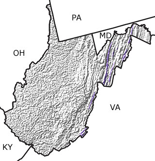
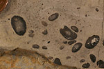
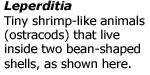
Paleontology and geologyDuring the Silurian, West Virginia was under water and the rocks of this period indicate a wide range of shallow marine and tidal environments. Early Silurian rocks are mostly nearshore and shallow marine deposits, including shales and sandstones rich in iron. These sediments represent materials eroding off land raised by mountain building during the Ordovician. By the Late Silurian, land had eroded to near sea level and little sand or mud reached the sea. The rocks from this environment consist of limestones deposited in shallow water marine settings and contain evidence of evaporites formed on tidal flats. These limestones are sometimes interbedded with red shales representing the periodic formation of subtropical deltas. Straight-shelled nautiloids and ostracodes are common fossils in West Virginias Silurian rocks. This map shows thin bands of Silurian rock in the eastern portion of the state. |
||||||||||||||||||||||||||||||||||||||||||||||||||||||||||||||
Links to more on the Silurian in West Virginia |
||||||||||||||||||||||||||||||||||||||||||||||||||||||||||||||
Research and Collections
|
||||||||||||||||||||||||||||||||||||||||||||||||||||||||||||||
|
site tour |
about the site |
site map |
site credits |
page credits |
help |
FAQs |
contact |
||