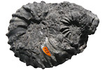
Paleontology and geologyA sea covered much of the western and central part of Nevada during the Triassic. Throughout the northern and central region, fine-grained limy mud accumulated on the continental shelf in water depths of 100 meters or more. Ichthyosaurs and ammonites swam about in this region and their fossils are found in abundance in the limestone formed from these sediments. One of the most famous sites for Triassic ammonoids occurs in the Great Basin Desert in central Nevada. To the south, the sea had receded and red sand dunes accumulated in inland deserts. Renewed tectonic processes created the Sonoma Mountains as deep ocean sediments were thrust eastward, up and over the eroded remnants of an older mountain range (the Antler Mountains). Volcanic islands developed offshore, farther to the west and north. |