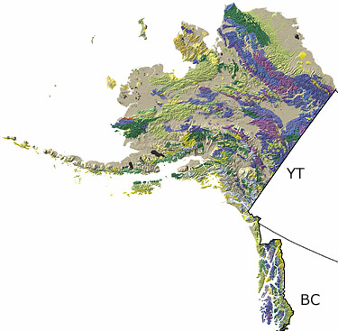
Paleontology and geologyThe Precambrian: Precambrian rocks are relatively rare in Alaska, and most of these are highly metamorphosed. Stromatolites and fossil bacteria in some Late Precambrian rocks indicate the presence of a shallow sea during this time.
The Paleozoic: During the Paleozoic, most of what would become Alaska was under water. Fossils of trilobites, brachiopods, and many other marine animals indicate the presence of a broad, shallow carbonate platform in the Cambrian. These rocks are particularly well-preserved in the east-central part of the state. Tectonic activity during the Ordovician and Silurian produced a series of volcanic islands in what is now eastern Alaska. Fossil corals and other organisms provide a record of the reefs that built up around these islands. During the Devonian, marine conditions continued in the northern third of the state, while the small slivers of continental crust and pieces of volcanic island arcs that would one day become south-central Alaska were as yet scattered or non-existent. Fossils of corals, brachiopods, ammonites, and gastropods, particularly abundant in the northern third of the state, indicate that a variety of marine environments existed in Alaska during the Carboniferous and Permian.
The Mesozoic: The various pieces of continental crust that would constitute modern Alaska began to assemble during the Mesozoic. Fossils of molluscs, icthyosaurs, bony fish, and other marine organisms record the presence of shallow marine conditions in the southern part of the state during the Triassic; deep marine waters covered the northern third of the state at this time. Volcanic activity was common. The Jurassic began an interval of intense tectonic activity in Alaska, and extensive volcanic eruptions generated igneous rocks that now form a belt through central Alaska. Fossil ammonites and crinoids indicate that the sea still covered parts of the state at this time. Throughout the Cretaceous, a series of continental and oceanic plates slammed into the state, adding to its landmass. The Brooks Range and other mountains rose and erosion of these mountains dumped huge amounts of sediment into low-lying areas. The fossil record indicates the presence of both marine and terrestrial environments. Dinosaur fossils have been found in Cretaceous rocks in Alaska.
The Cenozoic: Tectonic activity continued into the Cenozoic. Volcanism built up the Aleutian Islands during the Tertiary, and fluctuations in sea level intermittently exposed the Bering Land Bridge between Asia and Alaska. Glaciers covered much of Alaska during the Quaternary, but low sea levels exposed a corridor of land along the Bering Land Bridge, enabling migrations of animals and plants between Asia and North America. Volcanic activity continued in the Aleutians and what is now the Alaskan Peninsula. |