

Nunavut, Canada |
|||||||||||||||||||||||||||||||||||||||||||||||||||||||||||||||
|
|||||||||||||||||||||||||||||||||||||||||||||||||||||||||||||||
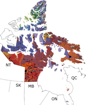
Paleontology and geologyThe Precambrian: Precambrian rocks in Nunavut belong to the Canadian Shield, the core of the North American continent. These The Paleozoic: Through the Paleozoic, mainland Nunavut was above sea level, while shallow to deep seas covered the Arctic islands. These warm waters were home to a great diversity of invertebrates, some of which built up reefs, as well as many different kinds of fish. In the middle Paleozoic, plants started to move onto land, and soon much of the territory was vegetated. Collisions with other islands and continental plates in the northern Arctic islands added pieces of land to Ellesmere Island and folded, faulted, and pushed up many rocks in that area. The Mesozoic: Most of Nunavut was above sea level in the Mesozoic, except for several Arctic islands, which were covered by shallow to deep waters of a marine basin. Forests and wetlands filled with seed-bearing and flowering plants covered the land, while the freshwater and marine habitats were home to many different invertebrates, fish, reptiles, and birds. At the end of the era, the Arctic Ocean opened up in the north, and later Baffin Bay began to form as Greenland rotated and collided with some of the northern islands. This activity brought magma up to the surface and folded, faulted, and metamorphosed rocks in the northern islands. The Cenozoic: In the Cenozoic, most of Nunavut was above sea level, and deposition was restricted to lakes, rivers, and low-lying areas. Baffin Bay opened up as Greenland collided with islands in the north, which pushed up rocks in that area. The land was covered with forests and wetlands of many plants that now grow only in warmer areas to the south. These habitats hosted a great variety of invertebrates, reptiles, and mammals. By the end of the era, glaciers developed on the mainland and several islands, and they formed much of the modern topography. Deposits on some of the islands contain marine fossils that testify to intervals of higher sea level between the glacial periods. |
|||||||||||||||||||||||||||||||||||||||||||||||||||||||||||||||
Links to more on Nunavut paleontology |
|||||||||||||||||||||||||||||||||||||||||||||||||||||||||||||||
|
Organizations | Education and Exhibits | Resources OrganizationsEducation and Exhibits Resources
|
|||||||||||||||||||||||||||||||||||||||||||||||||||||||||||||||

|
site tour |
about the site |
site map |
site credits |
page credits |
help |
FAQs |
contact |
||