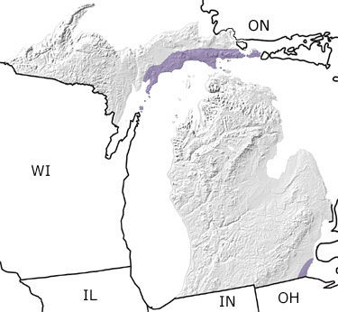
Paleontology and geologyShallow tropical seas persisted in Michigan during the Silurian. Deeper waters existed in an area now known as the Michigan Basin that includes the watershed areas of Wisconsin, Shallow tropical seas persisted in Michigan during the Silurian. Deeper waters existed in an area now known as the Michigan Basin that includes the watershed areas of Wisconsin, Illinois, Indiana, and Michigan that drain into Lake Michigan. Coral reefs grew around its edges, restricting water circulation into and out of the basin. The confined waters within the basin became hypersaline in nature. As evaporation continued, layers of salt and gypsum were deposited in shallow areas. Fossils of this period include corals, bryozoans, crinoids, trilobites, brachiopods, clams, snails, and cephalopods. This map indicates a band of Silurian rocks exposed along the northern shore of Lake Michigan. |