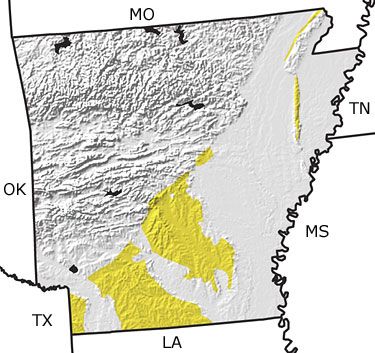
Paleontology and geologyThere was no tectonic activity in Arkansas during the Tertiary. The Ozark region in northern Arkansas and the Ouachita Mountains in central Arkansas were above sea level and undergoing erosion. During the Early Tertiary, rivers and streams transported sediments from these highlands to the shoreline of the Gulf of Mexico, which lay in what is now central Arkansas. Oysters and shark teeth are common fossils in these sediments. In the Middle and Late Tertiary, sea level fell, extending the shoreline south of its modern position. Rivers, including the ancestral Mississippi River, and swamps formed throughout southern Arkansas. The plant material buried in these swamps formed lignite, a low-grade coal. |