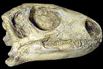
Paleontology and geologyImmense fields of sand dunes covered Utah in the Early Jurassic. These formed thick sandstones with large-scale cross-bedding. During the Middle Jurassic, Utah was inundated by a shallow sea, which is recorded today by the presence of limestones, shales, and evaporites. By the Late Jurassic, the sea had withdrawn and sediments were deposited in a complex pattern of terrestrial environments of coastlines, rivers, marshes, lakes, ponds, dune fields, and floodplains. Early Jurassic fossils consist primarily of footprints and trails made by vertebrates and invertebrates in lakes formed between the dunes. Middle Jurassic fossils are mostly marine: brachiopods, clams, snails, ammonoids, and ichthyosaurs. A diverse and abundant dinosaur fauna, as well as the amphibians, reptiles, and fish that were their contemporaries, dominates the Late Jurassic fossil record. |