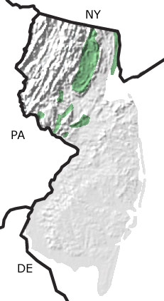
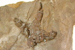
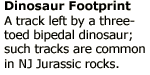
Paleontology and geologyDuring the Jurassic, the supercontinent of Pangea continued to break apart. Volcanic activity associated with this rifting produced lava flows that poured out over mudflats and into lakes, producing the resistant rock that forms today's Watchung Mountains. Molten rock intruded into basin sediments producing a sill, the Palisades Sill, and other ridges in Hunterdon and Mercer Counties. Bipedal dinosaurs roamed the basins during the Jurassic, leaving abundant footprints in the sediments layered among the lava flows. The Walter Kidde Dinosaur Park in Essex County boasts thousands of such footprints. Fossils of Semionotus, a fish related to the modern gar, are abundant in Jurassic lakebed sediments. This map indicates the presence of Jurassic rocks primarily in the northern part of the state. |