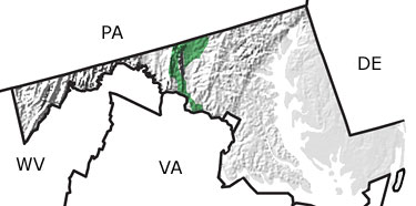
The Paleontology of North America

The Triassic in Maryland, US

 map
 

See exposures in this state from the:

Quaternary
Tertiary
Cretaceous
Jurassic
Triassic
Permian
Carboniferous
Devonian
Silurian
Ordovician
Cambrian
Precambrian

Triassic Fossils

No slide show is available for the Triassic in Maryland.

Paleontology and geology

During the Triassic, rift basins began to develop in central Maryland as plate movement started to pull apart the supercontinent of Pangea. Sediments washed into these valleys and accumulated as lake and river sediments, represented by layers of red shale, siltstone, and sandstone. Early dinosaurs roamed the landscape, leaving behind mostly footprints.

Delaware State Map Pennsylvania State Map Virginia State Map West Virginia State Map