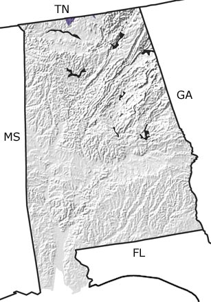
Paleontology and geologyDuring the Ordovician, most of the land that would become Alabama lay beneath a warm, tropical sea teeming with brachiopods, clams, trilobites, and other marine life. Rocks formed from sediments deposited on this sea floor are now exposed along the Tennessee border in the north-central part of the state.
A mountain-building event (Taconic Orogeny) occurred in the middle Ordovician. Layers of ash from associated volcanic activity and sediments eroding off the rising mountains were periodically deposited into the sea. Melting caused by the subduction of the crust during this orogeny produced massive plutons of granite-type rock. Although not shown on this map, these granitic rocks are now exposed at the surface across Alabamas Piedmont Province in the east-central part of the state. |