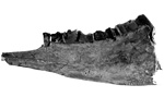
Paleontology and geologyIn the Tertiary, the Southwestern Region was pushed up as huge masses of granite formed beneath older rocks and volcanoes poured lava and ash over the surface. In the west, two oceanic plates met the continental plate, and their interactions changed. Subduction continued in the south, but to the north, the oceanic plate began to slide past the continent. As the oceanic plates split apart, the tear spread under the continent, creating a line of volcanoes across the northern part of this region. Between eruptions, the land was covered with forests of pines, deciduous trees, and tropical plants, as well as chaparral and grasslands. These habitats were home to birds, lizards, camels, rhinoceroses, peccaries, elephant relatives, bears, early cats and dogs, and other animals, some of which left footprints in muddy areas. Fish, frogs, salamanders, turtles, and crocodiles lived in the wetlands, lakes, rivers, and along the coasts. Farther out in the ocean, along another crack in the crust, volcanic eruptions began to form a mountain range, the highest peaks of which stick out as islands. |