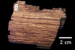
Paleontology and geologyDuring the Cretaceous, erosion continued to wear down the highlands around Nova Scotia, creating an extensive lowland plain. Lakes, rivers, and broad deltas developed over this plain, depositing thick sequences of sand, shale, and limestone. Now found offshore forming the Scotian Shelf that surrounds Nova Scotia, these rocks are economically important for their reserves of oil and gas. Onshore Cretaceous deposits have been discovered in several areas that were protected from erosion because they were preserved in sinkholes and depressions in older rocks. The deposits include gravels, sands, clays deposited by rivers and lakes, and they have not solidified into rock. Many of the deposits also contain remains of fossil plants, including conifers, ferns, and lycopsids. Some of the plant debris is in the form of charcoal, indicating that fires swept across the landscape during the Cretaceous, much like forest fires do today. |