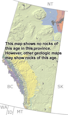
home   Printer friendly version Add to site
Advanced search
Time & Space Fossil Gallery Famous Flora & Fauna
Careers Resources K-12 Collections PaleoPeople

The Silurian in Alberta, Canada

Silurian in Alberta map

undifferentiated rock units help

Choose a time period:

Quaternary
Tertiary
Cretaceous
Jurassic
Triassic
Permian
Carboniferous
Devonian
Silurian
Ordovician
Cambrian
Precambrian

Silurian Fossils

No slide show is available for the Silurian in Alberta.

Search the fossil gallery

Paleontology and geology

In the Silurian, much of the province was above sea level and exposed to erosion. Shallow seas covered the continental shelf in the west and to the south. Many of the sandstones, mudstones, limestones, and dolostones deposited on the shelf have been removed by erosion. Some rocks are preserved below the surface under younger rocks in the southeast, and a few exposures can be seen in the Rocky Mountains. These exposures are too small to be found on this map, but other more detailed maps may include them.


Northwest Territories Province Map
Saskatchewan Province Map
Montana State Map
Idaho State Map
Washington State Map
British Columbia Province Map