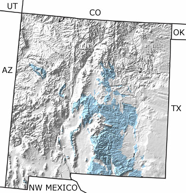
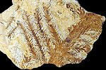
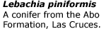
home   Printer friendly version Add to site
Advanced search
Time & Space Fossil Gallery Famous Flora & Fauna
Careers Resources K-12 Collections PaleoPeople

The Permian in New Mexico, US

Permian in New Mexico map

undifferentiated rock units help

Choose a time period:

Quaternary
Tertiary
Cretaceous
Jurassic
Triassic
Permian
Carboniferous
Devonian
Silurian
Ordovician
Cambrian
Precambrian

Permian Fossils
Fossil photos from Permian in New Mexico

Search the fossil gallery

Paleontology and geology

The Permian began with broad river floodplains lying north of a coastline that ran east-west across part of southern New Mexico (at about the latitude of Las Cruces). Drier climates followed, and dune fields appeared, but were eventually replaced by shallow, salty seas. More normal marine conditions returned during the middle of the Permian and a huge reef began to develop at El Capitan in southeastern New Mexico. Brachiopods, clams, and ammonites are typical marine fossils from this time period. This map indicates an extensive exposure of Permian rocks in the south-central portion of the state with smaller exposures to the west.

Links to more on the Permian in New Mexico

Resources

Resources

Courses and Lectures (showing 1 of 1 listings)

Paleogeography of the Southwestern U.S.: The paleogeography of the southwestern U.S. from 1.8 billion years ago to 10 million years ago. Text and images by Dr. Ron Blakey from Northern Arizona University.

top Top of List

Databases (showing 1 of 1 listings)

New Mexico Museum of Natural History and Science Web-based Paleo-database Home Page: Search the fossil collections of the New Mexico Museum of Natural History and Science. Listings by Kingdom down to species, era, epoch, group, formation, country, New Mexico county, and map ID. Many listings contain images of the fossils (including all holotypes.) 

top Top of List


Utah State Map
Arizona State Map
Colorado State Map
Oklahoma State Map
Texas State Map
Northwest Mexico Region Map