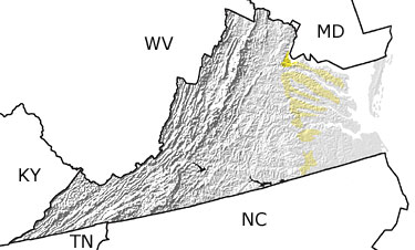
The Tertiary in Virginia, US

Tertiary in Virginia map
 

Choose a time period:

Quaternary
Tertiary
Cretaceous
Jurassic
Triassic
Permian
Carboniferous
Devonian
Silurian
Ordovician
Cambrian
Precambrian

Tertiary Fossils
Fossil photos from Tertiary in Virginia

Previous (8 slides) Next
Search the fossil gallery

Paleontology and geology

During the Tertiary, the Coastal Plain of Virginia experienced alternating intervals of erosion (as sea level fell) and deposition (as sea level rose). The Chesapeake Bay impact structure was formed 35.5 million years ago when an extraterrestrial object – perhaps a large meteorite – slammed into what is now Chesapeake Bay. The Yorktown Formation, exposed along the York River, is one of many sedimentary units that is rich in marine fossils such as whale bones, snails, and clams. This map indicates the presence of Tertiary rocks across the central-eastern part of the state.


Kentucky State Map
Tennessee State Map
West Virginia State Map
North Carolina State Map
Maryland State Map

site tour | about the site | site map | site credits | page credits | help | FAQs | contact
© | editorial policy | awards | teachers' guide | site generator | About RSS

paleontology news:   recent site additions: