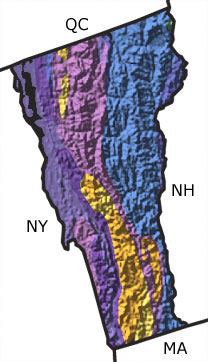
Vermont, US
|
|
|||||||||||||||||||||||||||||||||||||||||||||||||||||||||||||
Paleontology and geology
The Precambrian: The Precambrian of Vermont is represented only by metamorphic rocks. There are no Precambrian sedimentary rocks or fossils in the state.
The Paleozoic: The Paleozoic sedimentary record is sparse in Vermont. Tracks, trails, and fossils marine animals provide evidence that a shallow, warm sea covered what is now Vermont during the Cambrian and Ordovician. Tectonic activities during the latter part of the Ordovician caused the deepening of this sea and the uplift of the Green Mountains, part of the Appalachian Mountain chain. These mountains then eroded, and during the Silurian, the seas rose again and flooded eastern portions of the state. Another episode of mountain building (the Acadian Orogeny) occurred in the Devonian. Volcanic activity was common and the plutons beneath these volcanoes are exposed on the earths surface today. Metamorphism associated with the orogeny destroyed or altered any sediments formed at this time. The mountains uplifted during this period continued to erode during the Late Paleozoic (Carboniferous and Permian), and there are no rocks or fossils of this age preserved in Vermont.
The Mesozoic: The near absence of Mesozoic rocks in Vermont suggests that the area was subjected to high rates of erosion. There are some Cretaceous igneous rocks in western Vermont. These rocks formed from magma that intruded into older rocks during the rifting that opened the Atlantic Ocean when the supercontinent of Pangea broke apart.
The Cenozoic: Cenozoic deposits in Vermont are limited to the Quaternary, when a thick sheet of glacial ice covered the state. Fossils in lake deposits in westernmost Vermont indicate fluctuating levels of salinity, as the waters mingled with ocean water entering through the St. Lawrence River to the north. When the glaciers melted, the land rebounded, building a barrier to these ocean waters and producing freshwater lake conditions.
Links to more on Vermont paleontology
Education and Exhibits | Resources
Education and ExhibitsResourcesVirtual Exhibits (showing 1 of 1 listings)
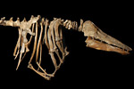
Charlotte, the Vermont Whale: This virtual exhibit details the story of a beluga whale skeleton found more than 150 miles from the nearest ocean.
Curriculum and Classroom Resources (showing 1 of 1 listings)
Teacher-Friendly Guides to Geology: Provides teachers with an intuitive and jargon-free review of the geology of different regions of the United States.