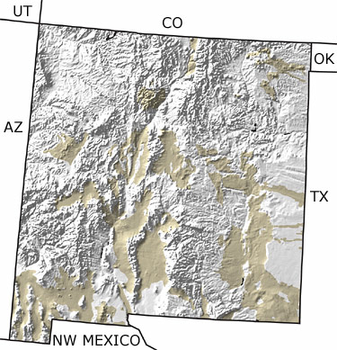
The Quaternary in New Mexico, US

Quaternary in New Mexico map

undifferentiated rock units help

Choose a time period:

Quaternary
Tertiary
Cretaceous
Jurassic
Triassic
Permian
Carboniferous
Devonian
Silurian
Ordovician
Cambrian
Precambrian

Quaternary Fossils
Fossil photos from Quaternary in New Mexico

Previous (3 slides) Next
Search the fossil gallery

Paleontology and geology

The final integration of the Rio Grande as the main river system in New Mexico took place during the Quaternary. Alpine glaciers were present in the northern mountains and even as far south as Sierra Blanca in south central New Mexico. This represented the southernmost extension of any glacier in North America. Large land mammals, such as mammoths and camels, roamed a landscape rich with forests of willows. This map indicates scattered exposures of Quaternary rocks throughout the state.

Links to more on the Quaternary in New Mexico

Resources

Resources

Databases (showing 1 of 1 listings)

New Mexico Museum of Natural History and Science Web-based Paleo-database Home Page: Search the fossil collections of the New Mexico Museum of Natural History and Science. Listings by Kingdom down to species, era, epoch, group, formation, country, New Mexico county, and map ID. Many listings contain images of the fossils (including all holotypes.) 

top Top of List


Utah State Map
Arizona State Map
Colorado State Map
Oklahoma State Map
Texas State Map
Northwest Mexico Region Map

site tour | about the site | site map | site credits | page credits | help | FAQs | contact
© | editorial policy | awards | teachers' guide | site generator | About RSS

paleontology news:   recent site additions: