British Columbia, Canada
|
|
|
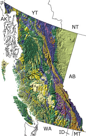
Paleontology and geologyThe Precambrian: The oldest rocks in British Columbia are 2.4 Ga metamorphic and igneous deposits that belong to the core of the North American continent. They are found below the surface in the northeast, and our knowledge of them comes from drill cores. After these rocks were formed, all the continents collided to form a supercontinent, with British Columbia near the center. When the supercontinent broke apart about 750 Ma, the eastern part of the province was at the edge of the continent, and sediments eroding off the land were deposited in the shallow seas covering the rest of British Columbia. Some of these sediments were deposited by glaciers that carried material from the land out to sea. The Paleozoic: For most of the Paleozoic, British Columbia was under water as part of the continental shelf and slope. Reefs developed in the warm, tropical seas, which were home to a variety of invertebrates. Many fossils of these animals are found in the province, the most famous of which are the rare, spectacularly preserved forms of the Burgess Shale. In the middle of this era, an island arc began to form near the western edge of the province and an ocean basin developed separating these volcanic islands from the continent. But by the end of the era, this ocean was closing, and these islands began to collide with the shallow shelf, while other parts of British Columbia were forming farther out to the west. The Mesozoic: At the beginning of the Mesozoic, subduction closed the ocean basin that separated a series of volcanic islands from the continent. As a result, fossils from this province record life in shallow to deep seas from North America as well as the ancient open ocean. Over time, these islands, slices of oceanic crust, and more islands from farther out in the ocean were added to the continent. All of these rocks were folded, faulted, and pushed to the east, forming large mountain ranges over the center of the province. By the end of the era, the province was being uplifted, and the mountains shed sediments into the Western Interior Seaway to the east. The late Mesozoic deposits preserve abundant plant fossils and dinosaur trackways. The Cenozoic: The Cenozoic was a time of substantial tectonic activity in British Columbia. The continental and oceanic plates continued to slide past each other along large faults, which brought magma up to the surface and uplifted the province. As a result, volcanoes formed up and down the coast. They also formed in the center where the province passed over a hotspot, and in the east where the crust was pulled apart. More recently, glaciers spread down from the mountains several times, gouging out valleys and fjords. Fossils from this era record many animals and plants that lived in the lakes, rivers, seas, and mountains of British Columbia. |
Links to more on British Columbia paleontology |
|
Organizations | Education and Exhibits | Research and Collections | Resources
Organizations
Societies and Clubs (showing 3 of 4 listings)
Geological Association of Canada's Paleontology Division: The division's activities, publications, and goals.
Vancouver Paleontological Society: Pages on the fossils of southwestern BC, fossils in general, how to collect fossils, and ethical concerns.
The Burgess Shale Geoscience Foundation: The BSGF is a non-profit educational organization based in Field, British Columbia. It was established in 1989 to increase the exposure of the general public to the Earth Sciences and in particular, to promote interest in Geology and Paleontology.
 More Societies and Clubs More Societies and Clubs
 Top of List Top of List
Parks (showing 1 of 1 listings)
The Burgess Shale: One of the world's most important fossil finds, the Burgess Shale, is located in Yoho National Park of Canada. Designated a World Heritage Site in 1981, the Burgess Shale Formation contains the fossilized remains of more than 120 marine animal species dating back 515 million years.
Top of List
Museums (showing 2 of 2 listings)
Courtenay & District Museum & Palaeontology Centre: This Vancouver Island museum has marine fossil exhibits and provides information about, and often tours of, local fossil sites.
Qualicum Beach Museum: This museum in Qualicum Beach, British Columbia, houses both paleontology and social history displays. The paleontology collection is one of the largest on the West Coast of Canada. The website will soon provide information on paleontology and social history displays.
Top of List
Government Agencies (showing 1 of 1 listings)
British Columbia Geological Survey: A great source of information on the geologic and mineral resources of British Columbia.
Top of List
Education and Exhibits
Virtual Exhibits (showing 3 of 3 listings)
Virtual Fossil Museum's Trilobites of Canada: Photos and information about exceptional trilobite fossils from Canada.
The Burgess Shale: This visually stunning online exhibition from the Royal Ontario Museum and Parks Canada, addresses aspects of history, research, education, outreach and visitor access to one of the most famous paleontological sites in the world. See amazing 3D animations, digital reconstructions and high-resolution images of the Burgess fossils. 
The Dawn of Animal Life: While most people know of the dinosaurs from a mere 70 million years ago, very few are aware that the Earth's fossil record stretches over 3 billion years into the past. Using exclusively Canadian rocks and fossils, this exhibit highlights almost three billion years of early evolution when only simple, soft-bodied creatures inhabited the Earth.
Top of List
Physical Exhibits (showing 1 of 1 listings)
Royal British Columbia Museum Natural History Gallery: The RBCM's gallery includes exhibits on Ice Age life in BC and environmental change over geologic time.
Top of List
Research and Collections
Ongoing Research Projects (showing 3 of 3 listings)
McAbee Fossil Beds: The McAbee Fossil Beds are found in the Tranquil Shale near Cache Creek, British Columbia. These 50-million-year-old (Eocene) shales are sediments of a shallow lake that existed at a time when the Northern Hemisphere had a warm temperate climate. The fossil record shows that this was a time when palm trees grew as far north as Alaska. Some five dozen plant species have been described from the Tranquil shale, including more than 40 broadleaf and some 17 conifer species. Sassafras, katsura and ginkgo plant fossils have been found, as well as a diversity of insects, fish fossils, and even some feathers.
Burgess Shale Research page at the Royal Ontario Museum: This page provides information on research being conducted at the Royal Ontario Museum on fossils from the Burgess Shale, with a list of recent publications. Links to press releases of important discoveries and podcasts are also provided.
Tumbler Ridge Museum and Dinosaur Centre: An series of photos and captions detailing the ongoing collection and description of dinosaurs from a new locality in British Columbia, Canada.
Top of List
Researchers (showing 1 of 1 listings)
The Palaeontology collections at the Royal British Columbia Museum: On the paleontological collections at the RBCM.
Top of List
Resources
Field Guides (showing 1 of 1 listings)
The Burgess Shale fossils: This site provides a description of the Burgess Shale and its stratigraphy, the Walcott quarry, and prominent fossil specimens (with photos) from this famous British Columbia locality.
Top of List
General Reference (showing 3 of 3 listings)
Geology of British Columbia: A description of the geologic and tectonic history of the province.
Enchanted Learning's Dinosaur Fossils Found in Canada: A list of dinosaurs found in Canada, by province.
Fossils of Northern British Columbia: A nice site with information on fossils in general, life through time from a BC perspective, BC fossil localities, and more.
Top of List
|
|