|
Choose from three main options:
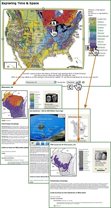
 Click
on any s-p-r (state, province or region) in the interactive map for: Click
on any s-p-r (state, province or region) in the interactive map for:
- a geologic/shaded-relief map of the s-p-r
- an overview of the paleontology and geology of the s-p-r through geologic time
- links to more information about the s-p-r's paleontology
- information about the State Fossil (U.S. only) or a slide show of representative fossils
 Choose from the time
period bar for: Choose from the time
period bar for:
- a map showing the shapes and positions of land masses and oceans
during that time period
- descriptions of the world geography and climate, and North American
geology and paleontology, for that time period
- a geologic/shaded-relief map of North America showing surface rocks
from that time period
- links to more information about that time period
 Select any combination
of s-p-r and time period (e.g., Wisconsin in the Cambrian or Ontario in the Silurian)
in the menus below the map for: Select any combination
of s-p-r and time period (e.g., Wisconsin in the Cambrian or Ontario in the Silurian)
in the menus below the map for:
- a geologic/shaded-relief map of the s-p-r showing surface rocks
from that time period
- a description of the paleontology and geology of
the s-p-r during that time period
- links to more information about the s-p-r during that
time period
- a slide show of up to eight images of fossils found in
the s-p-r in rocks from that time period
|
|


